Rabu, 05 Oktober 2011

Taman Mini Indonesia Indah

0 komentar
Taman Mini Indonesia Indah (TMII) or "Beautiful Indonesia Miniature Park" (literally translated) is a culture-based recreational area located in East Jakarta, Indonesia. It has an area of about 250 acres (1.0 km2). The park is a synopsis of Indonesian culture, with virtually all aspects of daily life in Indonesia's 26 (in 1975) provinces encapsulated in separate pavilions with the collections of Indonesian architecture, clothing, dances and traditions are all depicted impeccably. Apart from that, there is a lake with a miniature of the archipelago in the middle of it, cable cars, museums, a theater called the Theatre of My Homeland (Theater Tanah Airku) and other recreational facilities which make TMII one of the most popular tourist destinations in the city

History

This idea to build the smaller scale of Indonesia was originally came from former Indonesian first lady, Siti Hartinah or best-known as Tien Suharto. The idea came out at a convention on 8 Cendana Street at March 13, 1970. Through this recreational site, she hoped more Indonesian people will have more national pride than before.[1] The project called "Indonesian Miniature Project" was started by Harapan Kita Foundation in 1972. The concept of this culture-based recreational area was taken from the fact that Indonesia has unparalled richness and diversity from many different aspects.

Characteristics

TMII was originally located on a public area of 145 ha, as farms and fields. Later, the team was able to convert these fields into a suitable location for the construction. The topography of TMII is rather hilly, consistent with what the builders required. The team claimed the advantage of utilizing this uneven terrain was the ability to create interesting and diverse landscapes and enclosures, as well as reflecting the various characteristics of the Indonesian environment

Parts of TMII


Venues of Indonesian Provinces

Since each Indonesian province maintains its own unique and distinct cultures, shelters, attire and dialects, TMII built a model of each of the houses from Indonesian provinces. TMII attempted not only to reconstruct the homes of the various provinces, but also to create a realistic model of the environment and shelters of the various people of Indonesia.[2] The venues, which are situated around the main lake in a similar fashion to the different islands of the Indonesian archipelago, are thematically divided into six areas in respect to the main islands of Indonesia; Java, Sumatra, Kalimantan (Borneo), Sulawesi, the Lesser Sunda Islands, Maluku and Papua. Each pavilions featured in typical vernacular Indonesian architecture of each provinces. It also displays various traditional costumes, wedding costumes, dance costumes, also ethnography artifacts such as weapons and daily tools, models of traditional architecture are in display to describes the way of life of its people. Each provinces pavilions also equipped with small stage, amphitheatre or auditorium for traditional dance performances, traditional music performances or traditional ceremonies that usually held in Sundays. Some of these pavilions also equipped with cafetarias featuring traditional Indonesian cuisines and also souvenir shops offering various handycrafts, t-shirts and souvenirs.
Since 1975 until 2000s, the original design of TMII consist of a model of the houses from the 27 provinces of Indonesia, including East Timor. But after the secession of East Timor from Indonesia in 2002, the East Timor pavilion changed its status to become the Museum of East Timor. Also since Indonesia now consist of 33 provinces, currently the new province pavilions of Bangka Belitung, Banten, West Sulawesi, North Maluku, Gorontalo, and West Papua is being built in northeast part of the park.
After the recognition of Indonesian Chinese culture as the integral part of Indonesian culture in 2000, the new Indonesian Chinese pavilion and a Confucian temple was built within the park.

[edit] Religious Buildings

The religious buildings of several official faiths is meant to showcase the inter-faiths tolerance and religious harmony of Indonesia. The religious buildings are:

Gardens and Parks

There are about ten gardens spread within TMII complex, but most are located primarily on the north and northeast side of the main lake:
  • Orchid Garden
  • Medicinal herbs Garden
  • Cactus Garden
  • Jasmine Garden
  • Keong Emas (Golden Snail) Flower Garden
  • Fresh Water Aquarium
  • Bekisar (a type of rooster) Garden
  • Bird Park
  • Taman Ria Atmaja Park, stage and music performances
  • Taman Budaya Tionghoa Indonesia, an Indonesian Chinese cultural park (under construction)
  • Reptile Park in Komodo Zoological Museum compound. A fully grown Komodo dragon (Varanus komodoensis) nicknamed Bima resides in the reptile park near the eastern gate, which you can pet and take pictures with for Rp.5,000 ($0.60)

Museums

There are fourteen museums at TMII:
  • Indonesia Museum
  • Purna Bhakti Pertiwi Museum
  • Soldier Museum
  • Indonesian stamps Museum
  • Pusaka (Heirloom) Museum
  • Transportation Museum
  • Museum Electricity & New Energy Museum
  • Telecommunication Museum
  • Penerangan Museum
  • Sports Museum
  • Asmat Museum
  • Komodo Zoological Museum and Reptile Park
  • Insects Museum
  • Research & Technology Information Centre
  • Oil & Gas Museum
  • East Timor Museum (former East Timor province pavilion)

Theatres

  • Keong Emas (Golden Snail) Imax Theater
  • Tanah Airku Theater
  • 4D Theater

Monuments, Halls, Buildings and other Exhibits

  • Kala Makara main gates
  • Flower clock
  • Tugu Api Pancasila, the main monument, an obelisk celebrating Pancasila
  • Baluwerti, a twin gate with relief of Indonesian history on its wall
  • Pendopo Agung Sasono Utomo (Grand Hall), the main building in Javanese Joglo style
  • Sasono Utomo, exhibition hall
  • Sasono Langen Budoyo, indoor stage and theater
  • Sasono Manganti
  • Sasana Kriya handycraft center
  • Park Management Office
  • Cokot Sculpture, a display of wooden sculptures by Cokot, a famous Balinese artist
  • The Miniature of Borobudur
  • APEC Memorial Monument and Garden
  • Non Alignment Nations Friendship Monument and Garden
  • The Miniature of Indonesian Archipelago on central lake
  • Indonesian Archipelago Plaza and Stage
  • Jati Taminah, a remnant of a large teak tree
  • Kayu Gede (large wood), the display of large tree trunk

Prambanan Temple

0 komentar
Prambanan is a ninth century Hindu temple compound in Central Java, Indonesia, dedicated to the Trimurti, the expression of God as the Creator (Brahma), the Sustainer (Vishnu) and the Destroyer (Shiva). The temple compound is located approximately 18 km east of Yogyakarta city on the boundary between Yogyakarta and Central Java province.[1]
The temple, a UNESCO World Heritage Site, is the largest Hindu temple in Indonesia, and is one of the largest and the most beautiful Hindu temples in Southeast Asia. It is characterized by its tall and pointed architecture, typical of Hindu temple architecture, and by the towering 47m high central building inside a large complex of individual temples.[2] One of the most majestic temples in the Southeast Asia, Prambanan attracts many visitors worldwide

Construction

Prambanan is the largest Hindu temple of ancient Java, and the construction of this royal temple was probably started by Rakai Pikatan as the Hindu Sanjaya Dynasty's answer to the Buddhist Sailendra Dynasty's Borobudur and Sewu temples nearby. Historians suggest that the construction of Prambanan probably was meant to mark the return of the Hindu Sanjaya Dynasty to power in Central Java after almost a century of Buddhist Sailendra Dynasty domination. Nevertheless, the construction of this massive Hindu temple signifies that the Medang court had shifted the focus of its patronage from Mahayana Buddhism to Shivaist Hinduism.
A temple was first built at the site around 850 CE by Rakai Pikatan and expanded extensively by King Lokapala and Balitung Maha Sambu the Sanjaya king of the Mataram Kingdom. According to the Shivagrha inscription of 856 CE, the temple was built to honor Lord Shiva and its original name was Shiva-grha (the House of Shiva) or Shiva-laya (the Realm of Shiva).[4] Indeed, some archaeologists propose that the statue of Shiva in the garbhagriha (central chamber) of the main temple is modelled after King Balitung, serving as a depiction of his deified self after death.[5] The present name Prambanan, was derived from the name of Prambanan village where the temple stood, this name probably being the corrupted Javanese pronunciation of "Para Brahman" ("of the brahmins"), doubtless an echo its heyday when the temple was filled with great numbers of brahmins.
The temple compound was expanded by successive Mataram kings such as Daksa and Tulodong with the addition of hundreds of perwara temples around the chief temple. Prambanan served as the royal temple of the Hindu Kingdom of Mataram, with most of the state's religious ceremonies and sacrifices being conducted there. At the height of the Mataram kingdom, scholars estimate that hundreds of brahmins with their disciples lived within the outer wall of the temple compound. The urban center and the court of Mataram were located nearby, somewhere in the Prambanan Plain.

Abandonment

In the 930s, the court was shifted to East Java by Mpu Sindok, who established the Isyana Dynasty. An eruption of Mount Merapi volcano, located north of Prambanan in central Java, or a power struggle probably caused the shift. That marked the beginning of the decline of the temple. It was soon abandoned and began to deteriorate.
The temples themselves collapsed during a major earthquake in the 16th century. Although the temple ceased to be an important center of worship, the ruins scattered around the area were still recognizable and known to the local Javanese people in later times. The statues and the ruins become the theme and the inspiration for the Loro Jonggrang folktale. After the division of Mataram Sultanate in 1755, the temple ruins and the Opak River were used to demarcate the boundary between Yogyakarta and Surakarta (Solo) Sultanates.

Rediscovery

In 1811 during Britain’s short-lived rule of the Dutch East Indies, Collin Mackenzie, a surveyor in the service of Sir Thomas Stamford Raffles, came upon the temples by chance. Although Sir Thomas subsequently commissioned a full survey of the ruins, they remained neglected for decades, with Dutch residents carting off sculptures as garden ornaments and native villagers using the foundation stones for construction material.
Half-hearted excavations by archaeologists in the 1880s merely facilitated looting. Reconstruction of the compound began in 1918, and proper restoration only in 1930. Efforts at restoration continue to this day. The main building was completed around 1953. Since much of the original stonework has been stolen and reused at remote construction sites, hampering restoration and since a temple can be rebuilt only if at least 75% of the original masonry is available, only the foundations of most of the smaller shrines are now visible with no plans for their reconstruction

Contemporary events

In the early 1990s the government removed the market that had sprung up near the temple and transformed the surrounding villages and rice paddies into an archaeological park. The park covers a large area, from Yogyakarta-Solo main road in the south, encompassing the whole Prambanan complex, the ruins of Lumbung and Bubrah temples, and as far as the Sewu temple compound in the north. In 1992 the Indonesian government created a State-owned Limited Liability Enterprise (PERSERO) of PT Taman Wisata Candi Borobudur, Prambanan, dan Ratu Boko. This enterprise is the authority for the park management of Borobudur Prambanan Ratu Boko and the surrounding region. Prambanan is one of the most visited tourist attraction in Indonesia.
The open-air and indoor stages on the west side of the temple right across the Opak river, were built to stage the Ramayana ballet. This traditional Javanese dance is the centuries old dance of the Javanese court, performed every full moon night in the Prambanan temple since the 1960s. Since then, Prambanan has become one of the major archaeological and cultural tourism attractions in Indonesia.
After the reconstruction of the main temples in 1990s, Prambanan once again reclaim its status as an important religious center for Hindu rituals and ceremonies in Java. The religious significance revival of Prambanan was due to Balinese and Javanese Hindu communities in Yogyakarta and Central Java that annually perform their sacred ceremonies in Prambanan, such as Galungan, Tawur Kesanga, and Nyepi.[6][7]
The temple was damaged during the May 2006 Java earthquake. Early photos suggested that although the complex was structurally intact, the damage was significant. Large pieces of debris, including carvings, were scattered over the ground. The temple was closed to visitors until the damage could be fully assessed. Eventually, the head of Yogyakarta Archaeological Conservation Agency stated that it would take months to identify the precise extent of the damage.[8][9] However, some weeks later in 2006 the site was re-opened for visitors. In 2008, 856,029 Indonesian visitors and 114,951 foreign visitors has visited Prambanan. In 6 January 2009 the reconstruction of Nandi temple finished.[10]

Mount Bromo

0 komentar
Mount Bromo (Indonesian: Gunung Bromo), is an active volcano and part of the Tengger massif, in East Java, Indonesia. At 2,329 metres (7,641 ft) it is not the highest peak of the massif, but is the most well known. The massif area is one of the most visited tourist attractions in East Java, Indonesia. The volcano belongs to the Bromo Tengger Semeru National Park. The name of Bromo derived from Javanese pronunciation of Brahma, the Hindu creator god.
Mount Bromo sits in the middle of a vast plain called the "Sea of Sand" (Javanese: Segara Wedi or Indonesian: Lautan Pasir), a protected nature reserve since 1919. The typical way to visit Mount Bromo is from the nearby mountain village of Cemoro Lawang. From there it is possible to walk to the volcano in about 45 minutes, but it is also possible to take an organised jeep tour, which includes a stop at the viewpoint on Mount Penanjakan (2,770 m or 9,088 ft) (Indonesian: Gunung Penanjakan). The best views from Mount Bromo to the Sand Sea below and the surrounding volcanoes are at sunrise. The viewpoint on Mount Penanjakan can also be reached on foot in about two hours. From inside the caldera, sulfur is collected by workers.
Depending on the degree of volcanic activity, the Indonesian Centre for Vulcanology and Disaster Hazard Mitigation sometimes issues warnings against visiting Mount Bromo. The list of outstanding warnings may be consulted at the Indonesian-language website of the Centre.

CULTURE

On the fourteenth day of the Hindu festival of Yadnya Kasada, the Tenggerese people of Probolinggo, East Java, travel up the mountain in order to make offerings of fruit, rice, vegetables, flowers and sacrifices of livestock to the mountain gods by throwing them into the caldera of the volcano. The origin of the ritual lies in the 15th century legend where a princess named Roro Anteng started the principality of Tengger with her husband, Joko Seger. The couple were childless and therefore beseeched the assistance of the mountain gods. The gods granted them 24 children but stipulated that the 25th child, named Kesuma, must be thrown into the volcano as human sacrifice. The gods' request was implemented. The tradition of throwing sacrifices into the volcano to appease these ancient deities continues today and called Yadnya Kasada ceremony. Though fraught with danger, some locals risk climbing down into the crater in an attempt to recollect the sacrificed goods that believed could bring them good luck.
On the Segara Wedi sand plain sits a Hindu temple called Pura Luhur Poten. The temple holds a significant importance to the Tenggerese scatter across the mountainous villages such as Ngadisari, Wonokitri, Ngadas, Argosari, Ranu Prani, Ledok Ombo and Wonokerso. The temple organized annual Yadnya Kasada ceremony which lasts for about one month. On the 14th day, the Tenggerese will congregate at Pura Luhur Poten to ask for blessings from Ida Sang Hyang Widi Wasa and God of Mahameru (Mount Semeru). Then the mass will proceed along the crater edges of Mt Bromo where offerings will be thrown into the crater. The major difference between this temple with the Balinese ones are the type of stones and building materials. Pura Luhur Poten uses natural black stones from volcanoes nearby, while Balinese temples mostly made from red bricks. Inside this pura, there are several buildings and enclosures aligned in Mandala zone composition

ERUPTION

2004 eruptions

Mount Bromo erupted in 2004, that eruptive episode led to the death of two people

2010 eruptions

On Tuesday, 23 November 2010, 16.30 WIB (Western Indonesian Time), the Indonesian Centre of Vulcanology and Geology Hazard Mitigation (CVGHM) confirmed the activity status of Mount Bromo at "alert" due to increasing tremor activity and shallow volcanic earthquakes at the mountain.[4] Concerns were raised that a volcanic eruption may be likely to occur. As a precaution local residents and tourists were instructed to remain clear of an area within radius three kilometres from the caldera and refugee encampments were erected. The area surrounding the Teggera caldera of Bromo remained off limits for visitors throughout the remaining part of 2010.
Bromo started to erupt ash on Friday 26 November 2010.[
On 29 November 2010 Transport Ministry spokesman Bambang Ervan announced that Malang's domestic airport, would be closed until 4 December 2010. Malang a city of about 800,000 people is about 25 km (16 mi) west of Mount Bromo. Abdul Rachman Saleh Airport IATA:MLG normally handles 10 daily domestic flights from the capital Jakarta. Government volcanologist Surono reported that the volcano was spitting columns of ash some 700 metres (2,300 feet) into the sky

2011 eruptions

The Tengger Caldera was still active in late January 2011, the activity being characterised by fluctuating ongoing eruptions. On 23 January 2011 the Indonesian Centre for Volcanology and Geological Hazard Mitigation (CVGHM) (Pusat Vulkanologi dan Mitigasi Bencana Geologi) reported that since 19 December, 2010 volcanic ash and incandescent material had been thrown up by eruptive activity resulting in a heavy rain of material that fell around the crater. Continuous eruptions on 21 January caused a thin ash fall mainly in the village areas of Ngadirejo and Sukapura Wonokerto in Probolinggo district. The impact of a heavy rain of volcanic ash from eruptions since 19 December 2010 resulted in disruption of normal activities. By early 2011 concerns were being raised concerning the effect upon the local economy and the potential for long term environmental and health problems amongst the residents in the locality surrounding Mount Bromo. Due to high seasonal rainfall in January 2011 the potential for lahar and lava flow was raised due to the deposits of volcanic ash, sand and other ejected material that had built up. Seismic activity was dominated by tremor vibration and reports of visual intensity and sounds of eruption continued to be reported from the mountain monitoring facility, Bromo Observation Post. People living on the banks of the Perahu Ravine, Nganten Ravine and Sukapura River were alerted to the possibility of lava flows, especially when it was raining heavily in the area around Cemorolawang, Ngadisari and Ngadirejo. Eruptions and volcanic tremors were reported on 21 January and 22 January with activity subsiding on 23 January 2011. On 23 January, 2011 at 06:00 am the alert status at Mount Bromo remained at (Level III).[7]
On 23 January 2011 an exclusion zone was recommended for communities living around Mount Bromo. Tourists and hikers were to advised not to come within a radius of 2 km from the active crater. CVGHM stated that they expected warning signs to be installed stating the limit radius of 2 km from the crater. Operational caution was recommended for flights into and leaving Juanda International Airport IATA:SUB in Surabaya. CVGHM recommended the establishment of public areas for the provision of face masks and eye protection. CVGHM also issued a warning to residents to be cautious of ash build up on roofs and other places that may give cause for collapse under the burden of ash.[8]
Further eruptions and the issuing of Aviation Ash advisories on 27 January and 28 January 2011 led to concerns being raised regarding a volcanic ash plume, reported to be drifting eastward toward the air corridors used to access the Ngurah Rai International Airport IATA:DPS in Bali. Airport official Sherly Yunita was reported at the time as stating that concerns about visibility had prompted Singapore Airlines, Jetstar-ValueAir, Air France-KLM, Virgin Blue and Cathay Pacific to cancel several flights to Bali, 340 km (210 mi) to the east.[9][10] SilkAir also cancelled flights on the 27 January between Singapore and Lombok, an island to the east of Bali.[11] The Volcanic Ash Advisory Centre in Darwin, Australia


Deformation-late November 2010-late January 2011
  • Tiltmeter
The Indonesian Centre for Volcanology and Geological Hazard Mitigation (CVGHM) reported on 13 January 2011, that deformation using tiltmeter measurements indicated an inflation at rate of 5 micro radians between 25 November 2010 and 14 December 2010 and a relatively stable since 15 December, 2010 both on Radial Components and Tangential Components.
  • EDM
          Deformation measurement using EDM compared observations at designated measuring points;       POS-BRO, POS-KUR and POS-BAT during the period 25 November 2010 - 20 December 2010 with observations from the period 21 December 2010 - 30 December 2010 indicated the shortening of the distance from the POS-BAT, or inflation. Observations between 30 December 2010 to 23 January 2011 were reported as relatively stable

Tangkuban Perahu

0 komentar
Tangkuban Perahu (spelt Tangkuban Parahu in the local Sundanese dialect) is a dormant volcano 30 km north of the city of Bandung, the provincial capital of West Java, Indonesia. It last erupted in 1959. It is a popular tourist attraction where tourists can hike or ride to the edge of the crater to view the hot water springs and boiling mud up close, and buy eggs cooked on the hot surface.[2] This stratovolcano is on the island of Java and last erupted in 1983. Together with Mount Burangrang and Bukit Tunggul, those are remnants of the ancient Mount Sunda after the plinian eruption caused the Caldera to collapse.
In April 2005 the Directorate of Volcanology and Geological Hazard Mitigation raised an alert, forbidding visitors from going up the volcano. "Sensors on the slopes of the two mountains - Anak Krakatoa on the southern tip of Sumatra Island and Tangkuban Perahu in Java - picked up an increase in volcanic activity and a build up of gases, said government volcanologist Syamsul Rizal.

A study conducted in 2001 determined that Tangkuban Perahu has erupted at least 30 times in the previous 40,750 years. Studies of the tephra layers within 3 km of the crater revealed that twenty one were minor eruptions and the remaining nine were major eruptions. The eruptions that occurred prior to approximately 10,000 years ago were magmatic/phreatomagmatic. The eruptions that occurred after 10,000 years ago were phreatic


LOCAL LEGEND
The name translates roughly to "upturning of (a) boat" or "upturned boat" in Sundanese, referring to the local legend of its creation. The story tells of "Dayang Sumbi", a beauty who lived in West Java. She cast away her son "Sangkuriang" for disobedience, and in her sadness was granted the power of eternal youth by the gods. After many years in exile, Sangkuriang decided to return to his home, long after the two had forgotten and failed to recognize each other. Sangkuriang fell in love with Dayang Sumbi and planned to marry her, only for Dayang Sumbi to recognize his birthmark just as he was about to go hunting. In order to prevent the marriage from taking place, Dayang Sumbi asked Sangkuriang to build a dam on the river Citarum and to build a large boat to cross the river, both before the sunrise. Sangkuriang meditated and summoned mythical ogre-like creatures -buta hejo or green giant(s)- to do his bidding. Dayang Sumbi saw that the tasks were almost completed and called on her workers to spread red silk cloths east of the city, to give the impression of impending sunrise. Sangkuriang was fooled, and upon believing that he had failed, kicked the dam and the unfinished boat, resulting in severe flooding and the creation of Tangkuban Perahu from the hull of the boat.

Borobudur

0 komentar
Borobudur, or Barabudur, is a 9th-century Mahayana Buddhist monument near Magelang, Central Java, 
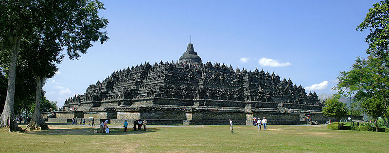
Indonesia. The monument comprises six square platforms topped by three circular platforms, and is decorated with 2,672 relief panels and 504 Buddha statues. A main dome, located at the center of the top platform, is surrounded by 72 Buddha statues seated inside perforated stupa.
The monument is both a shrine to the Lord Buddha and a place for Buddhist pilgrimage. The journey for pilgrims begins at the base of the monument and follows a path circumambulating the monument while ascending to the top through the three levels of Buddhist cosmology, namely Kāmadhātu (the world of desire), Rupadhatu (the world of forms) and Arupadhatu (the world of formlessness). During the journey, the monument guides the pilgrims through a system of stairways and corridors with 1,460 narrative relief panels on the walls and the balustrades.
Evidence suggests Borobudur was abandoned following the 14th-century decline of Buddhist and Hindu kingdoms in Java, and the Javanese conversion to Islam.Worldwide knowledge of its existence was sparked in 1814 by Sir Thomas Stamford Raffles, then the British ruler of Java, who was advised of its location by native Indonesians. Borobudur has since been preserved through several restorations. The largest restoration project was undertaken between 1975 and 1982 by the Indonesian government and UNESCO, following which the monument was listed as a UNESCO World Heritage Site.Borobudur is still used for pilgrimage; once a year Buddhists in Indonesia celebrate Vesak at the monument, and Borobudur is Indonesia's single most visited tourist attraction.

ETIMOLOGY
In Indonesian, ancient temples are known as candi; thus "Borobudur Temple" is locally known as Candi Borobudur. The term candi is also used more loosely to describe any ancient structure, for example gates and bathing structures. The origins of the name Borobudur however are unclear,although the original names of most ancient Indonesian temples are no longer known.The name Borobudur was first written in Sir Thomas Raffles' book on Javan history.Raffles wrote about a monument called borobudur, but there are no older documents suggesting the same name.The only old Javanese manuscript that hints at the monument as a holy Buddhist sanctuary is Nagarakretagama, written by Mpu Prapanca in 1365.
The name Bore-Budur, and thus BoroBudur, is thought to have been written by Raffles in English grammar to mean the nearby village of Bore; most candi are named after a nearby village. If it followed Javanese language, the monument should have been named 'BudurBoro'. Raffles also suggested that 'Budur' might correspond to the modern Javanese word Buda ("ancient") – i.e., "ancient Boro".However, another archaeologist suggests the second component of the name (Budur) comes from Javanese term bhudhara (mountain).
The references about the construction and inauguration of a sacred buddhist building — possibly refer to Borobudur — was mentioned in two inscriptions, both discovered in Kedu, Temanggung Regency. The Karangtengah inscription dated 824 mentioned vaguely about a sacred building named Jinalaya (the realm of those who have conquer worldly desire and reach enlightenment) inaugurated by Pramodhawardhani daughter of Samaratungga. The Tri Tepusan inscription dated 842 mentioned about the sima (tax-free) lands awarded by Çrī Kahulunnan (Pramodhawardhani) to ensure the funding and maintenance of a Kamūlān called Bhūmisambhāra.[11] Kamūlān itself from the word mula which means 'the place of origin', a sacred building to honor the ancestors, probably the ancestors of the Sailendras. Casparis suggested that Bhūmi Sambhāra Bhudhāra which in Sanskrit means "The mountain of combined virtues of the ten stages of Boddhisattvahood", was the original name of Borobudur.

LOCATION
Approximately 40 kilometres (25 mi) northwest of Yogyakarta, Borobudur is located in an elevated area between two twin volcanoes, Sundoro-Sumbing and Merbabu-Merapi, and two rivers, the Progo and the Elo. According to local myth, the area known as Kedu Plain is a Javanese 'sacred' place and has been dubbed 'the garden of Java' due to its high agricultural fertility.[13] Besides Borobudur, there are other Buddhist and Hindu temples in the area, including the Prambanan temples compound. During the restoration in the early 20th century, it was discovered that three Buddhist temples in the region, Borobudur, Pawon and Mendut, are positioned along a straight line.[14] It might be accidental, but the temples' alignment is in conjunction with a native folk tale that a long time ago, there was a brick-paved road from Borobudur to Mendut with walls on both sides. The three temples (Borobudur–Pawon–Mendut) have similar architecture and ornamentation derived from the same time period, which suggests that ritual relationship between the three temples, in order to have formed a sacred unity, must have existed, although exact ritual process is yet unknown.[9]
Unlike other temples, which were built on a flat surface, Borobudur was built on a bedrock hill, 265 m (869 ft) above sea level and 15 m (49 ft) above the floor of the dried-out paleolake.[15] The lake's existence was the subject of intense discussion among archaeologists in the 20th century; Borobudur was thought to have been built on a lake shore or even floated on a lake. In 1931, a Dutch artist and a scholar of Hindu and Buddhist architecture, W.O.J. Nieuwenkamp, developed a theory that Kedu Plain was once a lake and Borobudur initially represented a lotus flower floating on the lake.[10] Lotus flowers are found in almost every Buddhist work of art, often serving as a throne for buddhas and base for stupas. The architecture of Borobudur itself suggests a lotus depiction, in which Buddha postures in Borobudur symbolize the Lotus Sutra, mostly found in many Mahayana Buddhism (a school of Buddhism widely spread in the east Asia region) texts. Three circular platforms on the top are also thought to represent a lotus leaf.[15] Nieuwenkamp's theory, however, was contested by many archaeologists because the natural environment surrounding the monument is a dry land.
Geologists, on the other hand, support Nieuwenkamp's view, pointing out clay sediments found near the site.[16] A study of stratigraphy, sediment and pollen samples conducted in 2000 supports the existence of a paleolake environment near Borobudur,[15] which tends to confirm Nieuwenkamp's theory. The lake area fluctuated with time and the study also proves that Borobudur was near the lake shore c. 13th and 14th centuries. River flows and volcanic activities shape the surrounding landscape, including the lake. One of the most active volcanoes in Indonesia, Mount Merapi, is in the direct vicinity of Borobudur and has been very active since the Pleistocene.

HISTORY
1.Construkrion
There is no written record of who built Borobudur or of its intended purpose.[18] The construction time has been estimated by comparison between carved reliefs on the temple's hidden foot and the inscriptions commonly used in royal charters during the 8th and 9th centuries. Borobudur was likely founded around 800 AD.[18] This corresponds to the period between 760 and 830 AD, the peak of the Sailendra dynasty in central Java,[19] when it was under the influence of the Srivijayan Empire. The construction has been estimated to have taken 75 years and been completed during the reign of Samaratungga in 825.[20][21]
There is confusion between Hindu and Buddhist rulers in Java around that time. The Sailendras were known as ardent followers of Buddhism, though stone inscriptions found at Sojomerto suggest they may have been Hindus.[20] It was during this time that many Hindu and Buddhist monuments were built on the plains and mountains around the Kedu Plain. The Buddhist monuments, including Borobudur, were erected around the same time as the Hindu Shiva Prambanan temple compound. In 732 AD, the Shivaite King Sanjaya commissioned a Shivalinga sanctuary to be built on the Ukir hill, only 10 km (6.2 mi) east of Borobudur.[22]
Construction of Buddhist temples, including Borobudur, at that time was possible because Sanjaya's immediate successor, Rakai Panangkaran, granted his permission to the Buddhist followers to build such temples.[23] In fact, to show his respect, Panangkaran gave the village of Kalasan to the Buddhist community, as is written in the Kalasan Charter dated 778 AD.[23] This has led some archaeologists to believe that there was never serious conflict concerning religion in Java as it was possible for a Hindu king to patronize the establishment of a Buddhist monument; or for a Buddhist king to act likewise.[24] However, it is likely that there were two rival royal dynasties in Java at the time—the Buddhist Sailendra and the Saivite Sanjaya—in which the latter triumphed over their rival in the 856 battle on the Ratubaka plateau.[25] This confusion also exists regarding the Lara Jonggrang temple at the Prambanan complex, which was believed that it was erected by the victor Rakai Pikatan as the Sanjaya dynasty's reply to Borobudur,[25] but others suggest that there was a climate of peaceful coexistence where Sailendra involvement exists in Lara Jonggrang

2.Abandonment
Borobudur lay hidden for centuries under layers of volcanic ash and jungle growth. The facts behind its abandonment remain a mystery. It is not known when active use of the monument and Buddhist pilgrimage to it ceased. Sometime between 928 and 1006, King Mpu Sindok moved the capital of the Medang Kingdom to the region of East Java after a series of volcanic eruptions; it is not certain whether this influenced the abandonment, but several sources mention this as the most likely period of abandonment.The monument is mentioned vaguely as late as ca. 1365, in Mpu Prapanca's Nagarakretagama written during Majapahit era and mentioning "the vihara in Budur". Soekmono (1976) also mentions the popular belief that the temples were disbanded when the population converted to Islam in the 15th century.
The monument was not forgotten completely, though folk stories gradually shifted from its past glory into more superstitious beliefs associated with bad luck and misery. Two old Javanese chronicles (babad) from the 18th century mention cases of bad luck associated with the monument. According to the Babad Tanah Jawi (or the History of Java), the monument was a fatal factor for Mas Dana, a rebel who revolted against Pakubuwono I, the king of Mataram in 1709. It was mentioned that the "Redi Borobudur" hill was besieged and the insurgents were defeated and sentenced to death by the king. In the Babad Mataram (or the History of the Mataram Kingdom), the monument was associated with the misfortune of Prince Monconagoro, the crown prince of the Yogyakarta Sultanate in 1757. In spite of a taboo against visiting the monument, "he took what is written as the knight who was captured in a cage (a statue in one of the perforated stupas)". Upon returning to his palace, he fell ill and died one day later.


Krakatoa

0 komentar
Krakatoa (Indonesian: Krakatau) is a volcanic island made of a'a lava[2] in the Sunda Strait between the islands of Java and Sumatra in Indonesia. The name is used for the island group, the main island (also called Rakata), and the volcano as a whole. The island exploded in 1883, killing approximately 40,000 people, although some estimates put the death toll much higher. The explosion is considered to be the loudest sound ever heard in modern history, with reports of it being heard nearly 3,000 miles (4,800 km) from its point of origin. The shock wave from the explosion was recorded on barographs around the globe.

HISTORY
The best known eruption of Krakatoa culminated in a series of massive explosions on August 26–27, 1883, which was among the most violent volcanic events in modern and recorded history.
With a Volcanic Explosivity Index (VEI) of 6,[3] the eruption was equivalent to 200 megatons of TNT (840 PJ) – about 13,000 times the nuclear yield of the Little Boy bomb (13 to 16 kt) that devastated Hiroshima, Japan, during World War II and four times the yield of the Tsar Bomba (50 Mt), the largest nuclear device ever detonated.
The 1883 eruption ejected approximately 21 km3 (5.0 cu mi) of rock, ash, and pumice.[4]
The cataclysmic explosion was distinctly heard as far away as Perth in Western Australia, about 1,930 miles (3,110 km) away, and the island of Rodrigues near Mauritius, about 3,000 miles (5,000 km) away.[5]
Near Krakatoa, according to official records, 165 villages and towns were destroyed and 132 seriously damaged, at least 21,007 (official toll) people died, and many thousands were injured by the eruption, mostly from the tsunamis that followed the explosion. The eruption destroyed two-thirds of the island of Krakatoa.
Eruptions at the volcano since 1927 have built a new island in the same location, named Anak Krakatau (which is Indonesian for "Child of Krakatoa"). This island currently has a radius of roughly 2 kilometres (1.2 mi) and a high point around 300 metres (980 ft) above sea level, growing 5 metres (16 ft) each year.

Etymology and orthography

Although there are earlier descriptions of an island in the Sunda Strait with a "pointed mountain," the earliest mention of Krakatoa by name in the Western world was on a 1611 map by Lucas Janszoon Waghenaer, who labeled the island "Pulo Carcata." (Pulo is a form of pulau, the Indonesian word for "island"). About two dozen variants have been found, including Crackatouw, Cracatoa, and Krakatao (in an older Portuguese-based spelling). The first known appearance of the spelling Krakatau was by Wouter Schouten, who passed by "the high tree-covered island of Krakatau" in October 1658.[citation needed]
The origin of the Indonesian name Krakatau is uncertain. The main theories are:
  • Onomatopoeia, imitating the noise made by cockatoos (Kakatoes) which used to inhabit the island. However, Van den Berg points out that these birds are found only in the "eastern part of the archipelago" (meaning the Lesser Sundas, east of Java). (See Wallace Line).
  • From Sanskrit karka or karkata or karkataka, meaning "lobster" or "crab. (Rakata also means "crab" in the older Javan language.) This is considered the most likely origin.
  • The closest Malay word is kelakatu, meaning "white-winged ant. Furneaux points out that in pre-1883 maps, Krakatoa does somewhat resemble an ant seen from above, with Lang and Verlaten lying to the sides like wings.
  • Van den Berg (1884) recites a story that Krakatau was the result of a linguistic error. According to the legend, a visiting ship's captain asked a local inhabitant the island's name, and the latter replied, "Kaga tau" (Aku nggak tau)—a Jakartan/Betawinese slang phrase meaning "I don't know. This story is largely discounted; it closely resembles other linguistic myths about the origin of the word kangaroo and the name of the Yucatán Peninsula.
The Smithsonian Institution's Global Volcanism Program cites the Indonesian name, Krakatau, as the correct name but says that Krakatoa is often employed.[6] This has been attributed to a sub-editor at The Times (who may have typographically swapped the 'a' and 'o' of the Portuguese spelling) interpreting telegraphic reporting on the massive eruption of 1883.[7] Also, like Egypt a couple of decades earlier, Polynesia (South Pacific) was in vogue in the late 19th century, and the Polynesian-like suffix -oa (as in Samoa) may have caught on as a result.[citation needed] While Krakatoa is more common in the English-speaking world, the Indonesian Krakatau tends to be favored by others, including geologists. Rogier Verbeek seems to have started the modern convention of using Krakatau for the island proper and reserving Rakata for the main cone.

Etymology and orthography

Indonesia has over 130 active volcanoes,[8] the most of any nation. They make up the axis of the Indonesian island arc system, which was produced by northeastward subduction of the Indo-Australian Plate. A majority of these volcanoes lie along Indonesia's two largest islands, Java and Sumatra. These two islands are separated by the Sunda Straits, which are located at a bend in the axis of the island arc. Krakatoa is directly above the subduction zone of the Eurasian Plate and the Indo-Australian Plate where the plate boundaries make a sharp change of direction, possibly resulting in an unusually weak crust in the region.
Before the 1883 eruption, Krakatoa comprised three main islands: Lang ("long," now called Rakata Kecil, or Panjang), and Verlaten ("forsaken" or "deserted," now Sertung), which were edge remnants of a previous very large caldera-forming eruption; and Krakatoa itself, an island 9 km (5.6 mi) long by 5 km (3.1 mi) wide. Also there was a tree-covered islet near Lang named Poolsche Hoed ("Polish Hat," apparently because it looked like one from the sea) and several small rocks or banks between Krakatoa and Verlaten. There were three volcanic cones on Krakatoa: Rakata, (820 m/2,690 ft) to the south; Danan, (450 m/1,480 ft) to the north; and Perboewatan, (120 m/390 ft) to the north (Danan may have been a twin volcano)

Bunaken National Park

0 komentar
The Bunaken National Park is a marine park in the north of Sulawesi island, Indonesia. The park is located near the centre of the Coral Triangle, providing habitat to 390 species of coral. as well as many fish, mollusc, reptile and marine mammal species. The Park is representative of Indonesian tropical water ecosystems, consisting of seagrass plain, coral reef, and coastal ecosystems.
It was established as a national park in 1991 and is among the first of Indonesia's growing system of marine parks. It covers a total area of 890.65 km², 97% of which is marine habitat. The remaining 3% of the park is terrestrial, including the five islands of Bunaken, Manado Tua, Mantehage, Nain and Siladen. The southern part of the Park covers part of the Tanjung Kelapa coast.

GEOLOGY
North Sulawesi is considered to be a 'young' formation, of 5-24 million years of age. The region has undergone explosive volcanism 1.5-5 million years ago, which resulted in the volcanic tuff that characterizes the existing topography. Manado Tua is an inactive volcano formed in a classical cone shape and rising over 600 m above sea level, the highest elevation in the park. Bunaken Island also has volcanic origins with a significant amount of uplifted fossil coral. Nain Island is also a dome-shaped island, 139m in height. Mantehage Island is relatively flat and seems to be sinking into the sea. The island has extensive mangrove forest flats, partially separated by saltwater channels. Siladen is a low-lying coral sand island with no significant topography. Arakan-Wawontulap and Molas-Wori on the mainland of North Sulawesi are relatively flat areas at the base of volcanic hills. The absence of a continental shelf allows the coastal area of the park to drop directly down the continental slope. The sea depth between the islands of the park is 200 to 1,840 metres

FLORA AND FAUNA
A very rich coral ecosystem covers most of Bunaken National Park, dominated by fringing reef and barrier reef corals.There are about 390 species of coral recorded in the waters of the Park. A distinct feature is a 25-50 metre vertical coral wall which is inhabited by 13 coral genus. The seaweeds that can be found here include Caulerpa, Halimeda, and Padina species, while the dominant seagrasses, in particular in the islands of Montehage and Nain, are Thalassia hemprichii, Enhallus acoroides, and Thalassodendron ciliatum. The park is also abundant in different species of fish, marine mammals and reptiles, birds, molluscs and mangrove species.
About 90 species of fish live in the waters of the park, among them being the Emperor Angelfish, Almaco Jack, Spotted Seahorse, Bluestripe Snapper, Pinkish Basslet and Two-lined monocle bream. The species of mollusc include the Giant Clam, Horned Helmet Shells, Chambered Nautilus, and ascidians.
It is claimed that this park has seven times more genera of coral than Hawaii[5], and more than 70% of all the known fish species of the Indo-Western Pacific.
On land, the islands are rich in species of palm, sago, woka, silar and coconut. Among the animal species that live on the land and the beaches are Celebes Crested Macaque, Timor Deer, and Sulawesi Bear Cuscus. The mangrove forest of the Park contains, among others Rhizophora and Sonneratiaspecies. This forest is also rich in species of crab, lobster, mollusc, and sea birds such as gulls, herons, sea doves, and storks
HUMAN HABITATION AND TOURISM
The area is densely populated, with 22 villages inside the park comprising about 35,000 people. Most locals work as fishermen or farmers cultivating coconut, sweet potato, banana or seaweed for export, while a small number are employed in tourism as dive guides, boat operators and cottage staff. Tourism is strongly developed, with accommodation ranging from backpacker cottages to 5 star resorts.Between 2003 and 2006 the number of visitors ranged from 32,000 to 39,000 of which 8-10,000 were international visitors.


CONSERVATION AND THREATS
Bunaken National Park was formally established in 1991 and is among the first of Indonesia's marine parks. In 2005 Indonesia submitted an application to UNESCO for including the park on the World Heritage List.Despite its national park status and significant funding, the park has suffered a slow, continuous degradation due to a number of threats including coral mining, anchor damage, blast fishing, cyanide fishing, diving, and trash. The World Wildlife Fund provides conservation support in the National Park as part of the Sulu Sulawesi Marine Eco-region Action Plan. This includes participatory enforcement and patrol, which resulted in significant reduction of blast fishing